 |
| Lighthouse Beach |
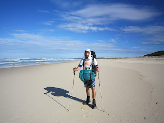
Again I was fortunate to share today's walk with another, Terry the lighthouse keeper. The morning being clear and sunny the mercury climbed quckly. After considerable consultation with national park staff regarding the intentions of my walk and the path which offered the greatest of sights, I made plans to follow the old gibber track which very roughly disected the park from south west to north east. This track would lead me towards Shelley beach on the southern shorline of Myall Lake then south west on to Myall Shore for restocking of water and supplies. However, Terry who had lived in the area for a number of years, assured me it would be far more enjoyable and quicker to follow the beach once again. The only obstacle was Big Gibber Headland.
Before setting off that morning I was under the presumption, based on Terry's advice, that the headland could be passed with little fuss. But as I was to find out this was not quite true. The large seas, a remnant of the significant weather system that had only started to clear yesterday, had driven the waterline further up the beach than Terry or I had ever expected. From an initial observation the headland could not be passed around the waterline as we had hoped. Terry first clammered around the relatively small rocky headland searching for a track across the top and I followed shortly afterwards, after attending to some pesky blisters. Terry soon discovered a very rough track leading towards the interior of the park but which soon disappeared. My gps maps backed up these observations but provided no definitive route around the headland to the southern beach. After 20 or so meters the track had been taken over by banskia, wattle, casurina, leptospermum and other natives along with the perenial pest Bitou bush.
 |
| My last view of Big Gibber |
 |
| A view south towards Hawkes Nest |
After saying farewell to Terry, who had decided to return home via the trechorous waters edge, I decided to set up camp for the night. Although I had imagined I would have been many kilometers down the beach by this time there was little to gain from pushing the journey on into the night. Plus the forced encampment allowed me time to enjoy the unique landscape and solitude.
Tomorrow I must get myself to Myall Shores to restock on water and supplies.
www.everydayhero.com.au/glen_hammermeister or
By calling Oxfam Australia on 1800 088 110.
Any donation great or small is sincerely appreciated.


No comments:
Post a Comment